EXPERTISE GALLERY
WHAT YOU WILL FIND IN THIS SESSION.
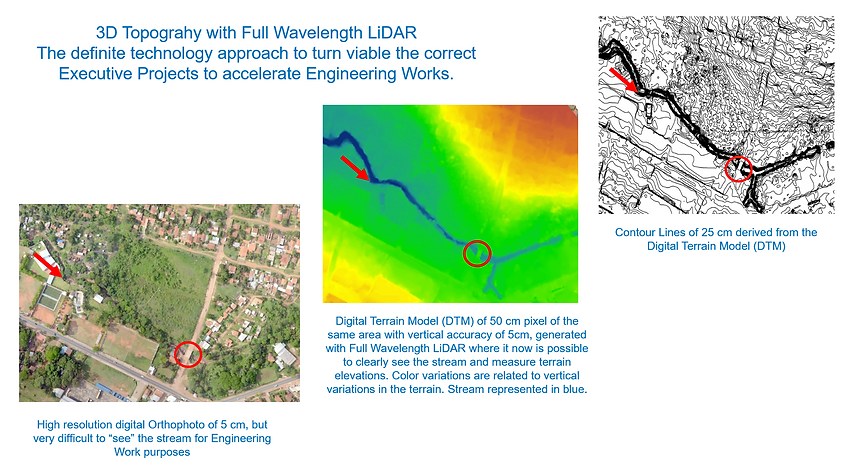
This Session presents examples of the main Projects and Activities that I have carried out during the last 36 years. You have the opportunity to download these examples from the pdf list under PROJECT GALLERY in the Menu. I will be adding more examples. Feel free to contact me on any subject. Provides a general overview on Territorial Sustainable Development, the main strategies for generating territorial references & monitoring. Innovation has always been present in my professional activities, from Geocadaster / GIS systems to GPS, Sensor Systems as CCDs, Thermal Infrared, Lidars, Radars, in airborne systems up to High Resolution Satellites.
In my conviction the concepts expressed in the picture below are of vital importance and they express what I have experienced and concluded in many opportunities throughout my life. The lack of Territorial References & Monitoring in Territorial Dynamics is the origin of most of the doubts, failures and mistakes in business and management decision making, from the Agribusiness Chain to Urban Planning, especially in Metropolitan Areas.
SUSTAINABLE TERRITORIAL MANAGEMENT
Sustainable Territorial Managent is only possible if there is Monitoring of the Territorial Dynamics. Down under is a Figure that ilustrates the situation without and with Monitoring. Impacts are mainly Administrative & Financial, and the scenario WITH monitoring is of great advantage.
Considerations about the importance of Assertive Planing
-
Time is the most valued asset and thus asks for planning and assertive management;
-
Figure above presents a comparison of what in many aspects is the existing scenario in many daily activities throughout the Globe, which contributes to undesired high levels or REWORK (loss of time & money) versus the solution approach of this Plan through monitoring of territorial dynamics that fosters public & private governance, among other benefits.
-
The monitoring of the territorial dynamics generates benefits to the Administrative & Financial Management of the territory of interest (rural or urban) for companies, institutions and governments;
-
Meet the administrative & financial needs for carrying out an assertive territorial planning and the later supervision and registry of the activities;
-
Reduce and eliminate “rework” that is embedded in many economic activities and that causes uncountable prejudices and a precious time loss.


Territorial Monitoring of the Agribusiness Chain


Urban Mapping & Monitoring